What Shall We Call the Bits?
As we develop the theme of this book further, we will be dealing with portions of the Earth's surface of every size, from small islands like Rottnest, right up through the parts and wholes of present continents and on to the complete cap of continental material which once covered the whole of the smaller Earth.The only name commonly in use for any of these areas is the word 'plate'. We will see shortly that this is not a particularly appropriate word. If a large plate is broken into a hundred pieces, is each of these a plate?
In this book, I will will using the general word 'domain' for areas of any size which have taken part in the Earth surface shifts described. This is on analogy with magnetic domains, the different magnetized areas of a magnetic material. These may be of any size, and if a large domain is split into a number of smaller parts, each of these is validly called a domain.
For larger domains, comparable in size to continents or the conventional tectonic plates, the form 'megadomain' will be used. However, a megadomain means something rather different to either a continent or a tectonic plate. The word 'continent' means a large, contiguous area of the Earth's surface which is above sea-level. We will see that none of the present continents is a simple megadomain, instead all are aggregations of one or more megadomains with a number of smaller parts.
In my view, so-called tectonic plates are just the areas within strings of different domain boundary segments which are currently in active movement. Different boundaries of the same domain will usually be undergoing different degrees of movement, at any one time the majority of them will be relatively stationary.
Thus a tectonic plate is not a real entity in any permanent sense. Its extent is only defined from the strings of active domain boundaries, and in reality some of these will be so inactive as to be included only to make up a complete figure. Hence the boundaries of 'plates' are only arbitrary, and their subjective nature naturally leads to arguments as to where particular plates extend to, or whether they are really several smaller plates.
Proposition 5A
A tectonic plate is not a real entity in any permanent sense,
but only the area within an arbitrary assembly of more or less
active parts of domain boundaries
Aggregates of smaller domains have been identified in various parts of the Earth, and to these the word 'terrane' has been applied. These will figure later on in the book. While I believe that 'terrane' is a valid concept and word, for consistency the term 'microdomain' will be used in this book.
For the complete cap of continental material covering the whole surface of the smaller Earth, the term 'holodomain' will be used.
The First Megadomains
We have seen from Chapter 4 that it is reasonably clear which of the major present land areas were part of the southern megadomain, Gondwanaland, and which belonged to its northern counterpart, Laurasia.Now we can go into the nitty-gritty of how, and why, it occurred. But first we need to look at some figures on land areas, which lead to a conclusion initially surprising, but obvious in retrospect.
It is accepted that Laurasia included most of Europe, North America, and Asia, and that Gondwanaland included most of Africa, South America, Australasia, and Antarctica. The land areas of these continents (in million square kilometres) is as follows:
| First Approximation: | |||
| Laurasia | Gondwanaland | Europe | 9.9 | Africa | 30.3 | N. America | 24.4 | S. America | 17.8 | Asia | 44.8 | Australasia | 8.5 | TOTAL | 79.1 | Antarctica | 14.0 | TOTAL | 70.6 |
|---|
We can see that the two megadomains were of roughly similar size, even on this crude first approximation. Refining these figures one stage more, we know that there is very strong evidence that India and Southeast Asia were part of Gondwanaland rather than Laurasia. These two regions have a total area of about 7.7m square kilometres. Subtracting this from Laurasia and adding it to Gondwanaland, we get:
| Second Approximation: | |||
| Laurasia | Gondwanaland | As above | 79.1 | As above | 70.6 | - India/SE Asia | 7.7 | + India/SE Asia | 7.7 | TOTAL | 71.4 | TOTAL | 78.3 |
|---|
On the second approximation, the two totals are a bit closer, but not satisfyingly so. Now is the time to bring in a point of detail of great importance.
Antarctica, the Fake Continent
We need to look more closely at the figure for Antarctica; it conceals a basic error which appears to have been ignored, in spite of readily available evidence. Antarctica is a fake continent. Much of its assumed land area is, in fact, sea -- or rather would be if the ice was melted. The South Pole itself lies some 1000 metres below sea level.This is not in any sense new information. It appeared, for example, in the 4th edition of the National Geographic Atlas in 1975, from which Fig. 5.1 is derived.
Figure 5.1 shows the conventional outline of Antarctica, and within it, the areas which are probably 'real' land, in the sense that they would be above sea level if the covering ice was removed and the sea allowed to flow in. In fact, only the part of Antarctica below Australia appears to contain a real landmass, the part below South America is actually only a chain of small islands. We still don't have the full picture, but as an approximation it appears that the real land area of Antarctica is only about half the 14 million square kilometres usually quoted.
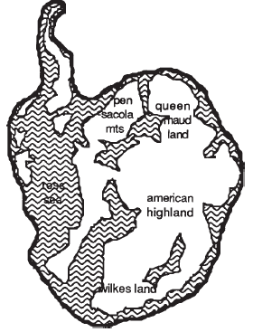
Fig 5.1. Commonly assumed and probable actual land areas in Antarctica
This point seems to have been completely ignored in previous reconstructions of how the continents fitted together in earlier times, whether on the old continental drift basis or using the newer expanding Earth approach. Nearly all these reconstructions have a great lumpy Antarctica stuck between Africa and Australia, and of course this strongly affects the matching.
Proposition 5B
Antarctica is not a real continent, but an assembly of islands,
with a land area probably totalling no more than half the 14
million square kilometres usually assumed
Laurasia and Gondwanaland were Equal!
When we adjust the Laurasia/Gondwanaland figures for this new smaller value for Antarctica, we get:| Third Approximation | |||
| Laurasia | Gondwanaland | As above | 71.4 | As above | 78.3 | TOTAL | 71.4 | - Half Antarctica | 7.0 | TOTAL | 71.3 |
|---|
and this agreement is excellent. Its relevance will be becoming apparent.
Of course, it is possible to go on into a Fourth Approximation. The areas of Central America, the Caribbean, California, Florida, Spain, Arabia, Atlas Mountains, Southern China, and Japan all contain a mixture of plant elements which make their positioning in either Laurasia or Gondwanaland a little less than certain. The exact land area of Antarctica is yet to be determined. Greenland is also partly a fake, as it is hollow, and the same may apply to other Arctic islands. But the general picture is clear -- Laurasia and Gondwanaland were close to having identical land areas.
Proposition 5C
The former megadomains of Laurasia and Gondwanaland
had the same surface areas
On now to the actual course of events. Assuming that there was once a solid 'skin' of continental matter covering the whole surface of the Earth, and this Earth then expanded under the skin so it split into pieces, how might we expect this to proceed?
Formation of the Equatorial Girdle
Well, the first thing which might happen is that the skin would split in half along the equator, into two equal 'caps', leaving a depressed 'oceanic girdle' around the Earth. This would be reasonable, both from the point of view of symmetry (where else would the line of weakness be?) and from a factor relating to conservation of momentum which we will look at later. And as further supporting evidence, we have the marked equality of area of Laurasia and Gondwanaland.Proposition 5D
The first major event in Earth expansion was the splitting of
the holodomain in half, along the Equator, to form the two
megadomains of Laurasia and Gondwanaland
There is considerable evidence for the past existence of such an 'oceanic girdle' , which has sometimes been called the Tethys or Tethyan Sea. In fact its existence has been a stumbling block to some of the earlier, pre-expansion theories of the development of the Earth. In NU013 (on fossil fuels) we shall also see an important implication of this equatorial marine girdle, which will be referred to here as the Tethyan Girdle.
What Happened Before the Split?
In postulating the Equatorial Split as the first major event of Earth Expansion, it is reasonable to ask what happened before it, to make it happen when it did. Why did the Earth suddenly undergo this paroxysm of expansion?I believe that there was no sudden event, the Equatorial Split was just a very obvious effect of processes which had been taking place for a long time previously. In this connection, we should look first at changes in the rate at which expansion has occurred in the past.
Carey has suggested [17] that the rate of Earth Expansion has been accelerating continuously during the measurable past. In earlier eras, the rate of expansion was slower, and the further you go back, the less the rate of expansion. It appears possible, in fact, that expansion has always been occurring during the Earth's physical evolution, but that the effects have only become really obvious as the rate has speeded up, especially in the last 200-400 my.
It appears that the distinguishing feature of the Equatorial Split was that this was the first occasion during which the skin of continental material covering the Earth was stretched thin enough to split open and expose the 'oceanic' rock material underneath. According to this scenario, movements of the material covering the Earth's surface had occurred previously, but these had only served to thin out the layer of lighter continental material, and not actually breach it.
Proposition 5E
The Equatorial Split which created the two megadomains of
Laurasia and Gondwanaland was notable for the first surface
exposure of underlying 'oceanic' material, as the overlying
continental material was thinned out by past expansion
We will pass on now to look at what happened subsequent to formation of the Equatorial Split, when Laurasia and Gondwanaland were themselves beginning to split into smaller parts. And here we can gather further evidence through looking at what happened to domains of different sizes; their size does seem to have had an effect on their subsequent behaviour.
Flight of the Microdomains
It appears that smaller land masses have travelled further from the Equator than have larger pieces to which they were once attached. This is reasonable if the larger pieces have centres of gravity close to the equator, so that the 'centrifugal forces' pushing part north and part south are more evenly balanced. On the other hand, a small landmass well north of the equator has no south-moving section to push against the north-moving urge, and so may be expected to move faster and farther north.As an example, look at Fig. 5.2, a map of areas of occurrence of fossil and modern hickories, taken from 'Tree Ancestors', a most interesting book by Edward Berry [9]. This can be compared with Fig. 4.11 in the previous chapter, showing the current distribution of Carya, the pecan and hickories.
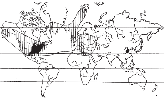
Notice that in addition to the modern areas, fossil remains of hickories have been found in Greenland, Iceland, Alaska, and even in tiny Svalbard (Spitzbergen), only a few degrees below the North Pole.
This leads to a most important point. The usual interpretation of Fig. 5.2 is that the climate in southern Greenland, Iceland, and the other fossil locations must once have been warm enough for hickories to grow there. While this may be true, the implied assumption that warmer climates once extended to much more northerly latitudes is not necessarily so. In reality, microdomains carrying these fossils may have individually moved north, out of warmer zones, after the fossils were deposited.
Proposition 5F
Fossils of warmer-climate plants found in areas with colder
climates may have been carried there by domain movement
If this proposition is true, it does of course throw confusion and doubt into the whole area of studies of climate in past eras (paleoclimatology). The same is true of other aspects of geology and Earth sciences which assume current parts of the planet were always in the same positions as now.
Proposition 5G
All areas of the Earth sciences which implicitly assume
a fixed Earth must be subject to detailed reconsideration in the
light of possible domain movements
This brings us to an interesting point about the movement of microdomains and the effect of their relative sizes. The evidence from the location of plant families is that smaller domains, such as Japan, Spain, New Zealand, Ireland, Florida, and California, are now in much more temperate latitudes than the larger masses to which they once appeared to relate. We will see some more detailed evidence on this point in what follows later.
Proposition 5H
In the movement of domains during Earth expansion and
continental drift, smaller domains have moved relatively further
from the Equator than larger ones
All the movements appear to have been away from the Equator and towards the poles. There may well be a quantitative formula somewhere in this. There is a complication, in that it seems possible that the position of the Equator has varied in the past [17], but for the moment we will not go into this.
Islands and Peninsulas
Small islands, such as Rottnest, are the clearest form of 'free' microdomain, portions of the Earth's surface which might be expected to show the clearest effects of expansion forces. We can now see a reason for the close parallel of the Rottnest vegetation with that on the mainland some 300 km further north, the point made at the start of NU002.Because of the way they have ventured further from the Equator than larger domains, islands often carry examples of 'tropical' life into temperate areas, examples which are not matched on adjacent larger domains. Rottnest is notable for having the most southernly examples of living corals in Western Australia.
Another example can be seen from Fig. 4.8, the distribution of the Sandalwood family. The species found on the tiny Juan Fernandez islands off Chile, and that in New Zealand, are moved well to the south, while that in Hawaii is well to the north of the main latitude of occurrence.
We can also see a reason for a most interesting point which concerns peninsulas. If you look at a world map, you can see that almost all the peninsulas in the northern hemisphere point south -- Baja California, Florida, Italy, Malaya, Korea, Sakhalin are all very obvious. In the southern hemisphere, the number of peninsulas is much smaller, but those that do exist mostly point north -- Cape York and Shark Bay in Australia are examples.
This pattern has a rational explanation if it is accepted that these peninsulas are merely island microdomains which have migrated away from the Equator at a faster rate than have larger domains, and have crashed into and joined up with other domains. Sometimes, as with the impact of Italy into northern Europe, the effects of the impact show up very clearly.
Proposition 5I
Peninsulas point south in the northern hemisphere,
and north in thesouthern hemisphere,
because they were formed by island microdomains
moving away from the Equator and joining with other domains
So far we have looked at isolated islands and half-isolated peninsulas (the latter word actually means 'half-island'!) as examples of microdomains. Now we move on to another type which has only been recognized as such comparatively recently.
The Microdomain Sideshuffle
In the first half of the 1980's, geologists came to an astonishing conclusion regarding the western coast of North America. Instead of being a single geological entity, the whole area was found to be a vast patchwork or collage of different rocks. These components, which were given the name 'terranes', were very varied in age and composition, and some of them appeared to be fragments broken off from much bigger deposits which today are located many thousands of kilometres away [43; 33].Since that time, a similar patchwork has been found to apply to the northeast coast of the USSR [46], and, of course, this area (Fig. 5.3) is just the analogue of the northwest American coast on the other side of the Pacific.
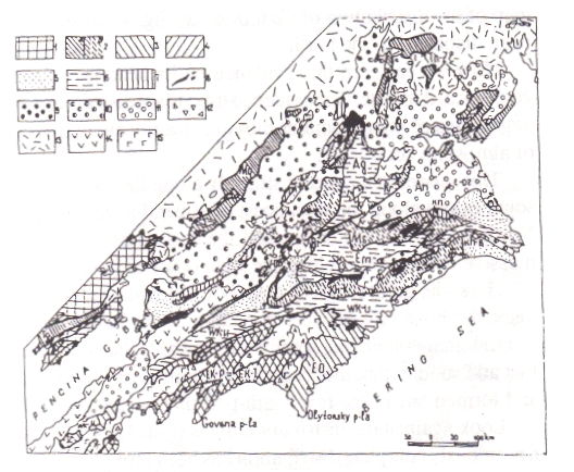
Fig. 5.3. Collage of microdomains (terranes) on northeast coast of the USSR
In both these areas, the same factor was found to be operating as with the island microdomains, that is, the components were generally much further north than comparable larger deposits to which they may have once been attached. In fact, it appears no longer in dispute that both these coastal areas are continuing to move north relative to the larger continental masses to which they are attached.
From what has already been shown in this book, it is obvious that this behaviour fits in very comfortably with the idea of assemblies of microdomains, together fleeing away from the Equator, and jostling and shuffling among themselves as they go.
In fact the terranes are merely random lots of island microdomains which have in some way been accreted on to the continents.
Proposition 5J
Terranes are random lots of microdomains which have
accreted to larger domains
The conventional mechanism for this is that rock welling up at the mid-ocean ridges is swept out and subducted under the adjacent continents, scraping off the islands as it goes, but we have seen that this mechanism cannot be accepted. And of course it would not account for the occurrence of a plant family right along chains of islands and onto a continent. This is the opposite to what would be expected if the islands were running into the continent, rather than the continent retreating and leaving islands behind it.
We have seen that the evidence from plant distributions strongly supports the idea that the Earth has expanded under the former distributions, splitting them apart, and does not require any specific 'accretion' mechanism. For example, we have seen that peninsulas would be expected to occur through the chance impact of faster-moving island microdomains with larger, slower domains. We will shortly see, however, that there may be a secondary 'accretional' factor operating.
The specific case of the U.S. west coast fits in very comfortably with the plant distributions. California has native palms, which we will see later are typical Gondwanaland plants, and the map of the distribution of Castanopsis (Fig. 4.12) shows how the American component has been displaced to the north.
Now we can turn this evidence on its head and make some massive predictions about geological deposits. The evidence from plant distributions is that microdomain shuffling, with aggregates of microdomains moving steadily away from the Equator, occurs down the sides of almost all continents.
This movement appears strongly along the east coasts of Africa and of Australia, and to some extent along the west coast of Australia (carrying Rottnest with it), the west coasts of North America and Europe, and the east coasts of Asia and North America. But its most massive expression is along the west coast of South America.
Here, the great range of the Andes Mountains, both very high and very long, appears to mark the boundary between the main South American megadomains and a huge army of microdomains shuffling southwards towards the pole. This huge system has been running so fast and so long that the leaders have spilled off the end of the continent at Tierra del Fuego and formed one of the few south-pointing peninsulas in the southern hemisphere.
Look again at the distribution maps (Fig. 4.1 to 4.14). All are consistent with the view that a previously complete distribution has been broken up and shifted, and that especially marked shifts away from the Equator have occurred with islands, peninsulas, and microdomain shuffle belts. In particular, the cycad map (Fig. 4.13) is very informative; the suggested forces provide a very satisfactory explanation for the observed distribution, extending north to Japan and Florida, south to southern Africa, Madagascar, and Chile. This distribution has been one which has puzzled researchers in the past, and as far as I am aware, no alternative explanation has ever been given for it.
Proposition 5K
Bands of microdomains are shuffling away from the Equator
along the sides of continents, particularly the west coasts of South
and North America and the east coasts of Australia and Africa
There is perhaps one subsidiary point about South America which deserves comment. This landmass has a strong bulge on the northwest. If this bulge, and the western coast to its south, is made up of microdomains, why haven't they split off into island strings as they strive to go south?
This is not a vital matter, but it does raise the possibility that gravitational attraction from an adjacent megadomain may be sufficient to make the microdomains cling to the side of the larger mass even as they shuffle on their way in a predominantly southern direction.
Proposition 5L
Microdomain movement directly away from the Equator may be somewhat distorted by the gravitational influence of adjacent megadomains
So far we have looked at the behaviour of the smaller domains, as islands, peninsulas, and as aggregated shuffle belts. When we move up to domains of intermediate size, we find the same sort of relocational behaviour, expressed less strongly.
The Creeping Slabs
There are a number of medium-sized bits of the holodomain which provide clear examples of intermediate-level shifts. One of these is the Iberian Peninsula -- Spain and Portugal.Figure 5.4 is a map of the Iberian Peninsula and the African coast to the south. Notice that the Iberian domain would fit almost exactly against the northwest coast of Africa. Notice also that the Pyrenees mountains look exactly as one would expect if formed by Iberia running north into what is now southwest France.
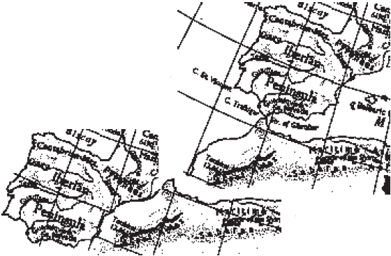 Fig. 5.4. The Iberian domain and northwest Africa
The plant evidence also supports this relocation. Spain has the only palm native to Europe, and the only yam (Dioscorea) found there. Both these plants are clear Gondwanan elements.
The whole of the lower east coast of the United States is now accepted as having split off from Africa in the past and drifted north. The boundary lies along the Appalachians, and the sub-surface join position has actually been identified to within a few kilometres [41]. It is not known for sure whether this area is a relatively simple slab, or is a complex microdomain belt.
Both these slabs are in a position we would expect, well north of the megadomains to which they were once attached, but not as far north as associated microdomains. Ireland, for example, was once probably attached to northern Portugal, but has now moved further on.
Perhaps the biggest of the creeping slabs is India. It is interesting that the whole of India is now well north of the Equator, although it is undoubtedly a Gondwanan domain. We will have a possible explanation for this later.
Here Come the Biggies
When we come to look at the movement of the major land masses, a similar picture is found -- movement has occurred, but for the bigger domains, this has been only small. Africa, the largest of the 'original' continents left, has its centre of gravity not far from the present Equator (about 6°), while South America, a little over half Africa's size, has its centre about 14° south. Australia, much smaller than South America, has its centre of gravity about 25° south.There is an important point here. None of the present continents are simple, unaltered megadomains, none are unchanged pieces of the original holodomain. Perhaps the three southern continents just mentioned are closest to unchanged, but even these show evidence of accretions (as in the area of Africa north of the Atlas Mountains), microdomain belt shuffling, and re-seaming.
Proposition 5M
None of the present continents is a simple megadomain, all
show evidence of accretion, microdomain shuffle belts, or
domain re-seaming
In the case of Australia, it is possible that, while the current eastern and western parts of the continent were always close together, the whole of the east has slipped north or south relative to the west. Similar shifts are likely for North America.
Easily the most re-seamed current continent is Asia. This is made up of a mega-collage of at least twenty major domains; every 'internal' mountain range, every long thin depression or lake (such as Baikal), represents a domain boundary which was active in the past. These points will be important when we look, in NU007, at what is involved in trying to fit the holodomain back together.
Continental Shelves and Domain Edges
A point which has attracted considerable debate in the past has been that of where to mark the edges of the domain units which have figured in Continental Drift. In fitting together the domains, many workers have taken the domain edges to lie at the margins of the continental shelves.There has been no general agreement as to the exact sea-level depth at which the shelf edges are to be drawn, but in many cases there exist abrupt changes in slope of these shelves which make their edges obvious in position. Sometimes investigators have been able to obtain better fitting of reconstructed domain assemblies using domains with associated continental shelves, than was possible using the 'naked' domains without them.
There is some conflict here with the point that it is theoretically possible to reconstruct the holodomain with a fairly high degree of accuracy. The uncertainty is no more than 100 km, it could be as little as 10 km, and in any case much less than the width of some continental shelves. The basis of reconstructions using the plant distribution methods I have advocated do, of course, use the naked domain boundaries. In fact I am asserting that for accurate reconstructions, domain boundaries should be taken as the present boundaries, at sea level.
Proposition 5N
In making Earth-expansion reconstructions, domain
boundaries should be taken as the present sea-level or abutment
boundaries, ignoring continental shelves
There is justification for this somewhat arbitrary decision. If the continuous nature of Earth Expansion suggested above is true, it simply means that continental shelves are later-event phenomena, produced after the initial continental-rock domains have split apart, through a further splitting of the 'shallow seabeds' produced during an earlier phase of expansion.
Profiles of the Ocean Floors
This view is supported by the actual conformation of the present-day seabeds. Rather than being huge sloping underwater 'valleys', these seabeds actually consist mostly of plateaus and flat plains, at varying levels below sea-level. The inference is that they were produced by Earth expansion processes in which domains of every size, both below and above sea-level, spread apart to leave essentially level or slightly inclined features, only later modified by erosional and domain interaction processes to lose some of this planarity.Why pick sea-level as the datum point? It is accepted that sea levels have varied greatly, all over the world, during all past ages. In fact, as we shall see in Chapter 10, Earth expansion is one of the principal factors active to cause variations in sea level.
The point is, that the edges of domains produced by the splitting apart of bigger domains are not greatly altered by subsequent events, at least not on the scale on which we are working, say in distances of up to 100 km. On this scale, the current sea-level boundaries of land domains bordering on the sea are an accurate enough indication of their edge positions in the past.
Does Erosion Make or Destroy Domains?
Obviously erosion on land will reduce the height of features and will tend to carry material out to sea, but, if there are no other factors operating, erosion is unlikely to extend or reduce a coastline by much more than about 10 km. And, while there are admittedly huge depths of sedimentary rock built up in some deposits, these are often due to relatively localized forces, such as the infilling of river valleys or undersea outwash fans from turbidity currents acting like underwater rivers. They do not really represent actual removal or formation of even medium-sized domains. The true picture is probably that land domain boundaries are merely smoothed and blurred by erosional forces, rather than being formed by them.Underwater, of course, erosion in the sense understood for land surfaces is almost absent. There is some scouring from the turbidity currents referred to, but most underwater forces, such as the powerful ocean currents, do not carry enough solid material to effectively erode features.
The other factor affecting domain boundaries is when they collide or slide relatively to one another. We will look at this in more detail in NU009, but the fact remains that these impacts, while producing very visible features on the Earth's surface, seldom change the delineation of the domains involved by more than a few kilometres. This can be seen from a consideration of the actual rock volumes involved.
Undoubtedly one of the most major expressions of the effects of domain collisions is to be found in the Himalayas area. There the Earth's highest mountain, Everest, reaches a height of almost 9 km. But this height is superimposed upon that of the vast plateau of Tibet, averaging around 5 km above sea level -- so the increment is only 4 km. We can refer to an increment of this size as 'only' when it is compared to the thickness of the domains at that point, these are at least 40 km thick, that is the thickness of the continental rock there.
So Everest, the biggest pimple on the planet, represents a variation of only about 10% in domain thickness, much less if its average rather than maximum height is considered, since most of its mass is at the base. It is clear that the material needed to make Everest could originate from only 2-3 km of domain edge material squashed together.
Proposition 5O
The boundaries of domains have been modified by shifts of
only a few kilometres as a result of erosional and impact forces
in their past.
We have now have looked, in some detail, at how the Earth fell apart. In the next chapter we will look at some of the further evidence available to be used in the job to come, that of putting it all back together.

(Full list of references at NURefs)
[9]. Edward W Berry. Tree ancestors.. Williams & Wilkins, Baltimore, 1923.
[17]. S W Carey. Lecture. Geology Department, University of Western Australia, 1987.
[33]. Rick Gore. Our restless planet Earth. Nat. Geographic/ 168(2) p142-181, 1985.
[41]. Hidden graft. Scient American/ Sept :53-54. 1985.
[43]. David G Howell. Terranes. Scient Amer/ Nov p90-103, 1985.
[46]. A Koltypin. The role of allochthonous terranes in construction and evolution of the Pacific continental margins (far north east USSR). In: Pacific (1987)/ p251-254, 1987.
NU006: More Distributions And Evidence
NU004: The Distributions Of Nut Trees
Version 2.0, 2004, PDFs etc on World Wide Web (http://www.aoi.com.au/matrix/Nuteeriat.htm)
Version 3.0, 2014 Sep 18, Reworked from Chapter 5 of "Nuteeriat" as one article in a suite on the World Wide Web.